


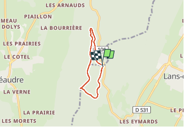
Croix Perrin balade 1

pconte
User

Length
4.5 km

Max alt
1303 m

Uphill gradient
124 m
Km-Effort
6.2 km

Min alt
1211 m

Downhill gradient
124 m
Boucle
Yes
Creation date :
2022-05-28 13:44:09.0
Updated on :
2022-05-28 15:08:05.293
1h23
Difficulty : Medium

FREE GPS app for hiking
 SityTrail
IGN / Geographical institutes
SityTrail Plus
The world is yours!
About
Trail Walking of 4.5 km to be discovered at Auvergne-Rhône-Alpes, Isère, Autrans-Méaudre en Vercors. This trail is proposed by pconte.
Positioning
Country:
France
Region :
Auvergne-Rhône-Alpes
Department/Province :
Isère
Municipality :
Autrans-Méaudre en Vercors
Location:
Méaudre
Start:(Dec)
Start:(UTM)
701215 ; 5000625 (31T) N.
Comments